


Research: Alaska's dissolving coastline, like melted butter on a hot, sunny day
by Kathleen McCoy |
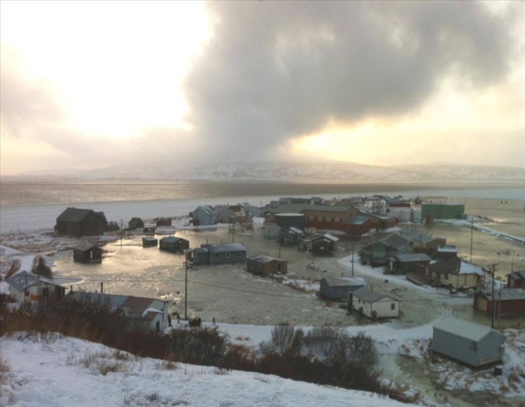
Golovin under water after a 2011 storm incident. (Photo by John Peterson of Golovin, provided by Nicole Kinsman/DNR and Thomas M. Ravens/UAA)
Alaska's coastline is melting. At Cape Halkett on the North Slope, half a football field dissolves into the sea each year.
"It's very dramatic," says UAA civil engineering professor Tom Ravens. "It's like melted butter on a hot sunny day. Before you know it, it's just liquid."
Watch it happen right before your eyes in a 38-second time-lapse video. The USGS filmed Drew Point (just down the coast from Cape Halkett) for a month in June 2008. At 28 seconds in, blocky chunks of coastline collapse into the sea and melt away like ice cubes in a cocktail.
Permafrost here is 70 percent water by volume, Ravens says, with just very fine particles frozen within. When the ice block that is the coast melts, no significant rocks or rubble remain to protect the shoreline from the next storm. And so away goes the coast.

Tom Ravens poses for a photo with the water flume in the Engineering and Industry Building on the University of Alaska Anchorage campus in Anchorage, Alaska Wednesday, Aug. 12, 2015. (Photo by Phil Hall/University of Alaska Anchorage)
This is Ravens' realm: coastal erosion and flooding. Nowadays in Alaska, he has plenty of work.
The professor retains just a hint of an East Coast accent. He earned early degrees at Dartmouth, a master's in philosophy from the University of Massachusetts and a doctorate in civil and environmental engineering from MIT. He served the Peace Corps in Nepal before eventually settling in at Texas A & M in Galveston to work on gulf coast erosion and design of salt marsh restoration projects.
Eight years ago, Alaska lured him north. He brought all he'd learned from the gulf, with the exception of one unfamiliar element: permafrost.
"You have all the same mechanical forces at work," Ravens said, "but here, you have thermal forces as well." The new challenge excited him.
An early project took him to the delta between the Yukon and Kuskokwim rivers, a place battered by frequent and severe fall storms. Offshore ice that used to protect the coastline has disappeared, and rising sea levels amplify the encroaching water's reach. Parts of the delta are even sinking. Flooding and erosion are very common.
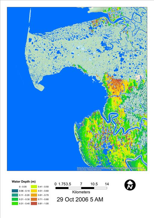
Sample of an inundation map of Hooper Bay from a fall storm in 2006. Chevak and Hooper Bay are two communities in this area. Red areas are covered up to a meter in water, or almost 40 inches. Pale green/yellow areas are up to a half meter, or 20 inches. (Created by Jon S. Allen/University of Alaska Anchorage)
With funding from the USGS and the U.S. Fish and Wildlife Service's Landscape Conservation Cooperative (which organizes research among agencies in a geographic region, avoiding duplication), Ravens and graduate student Jon S. Allen created a storm surge model capable of illustrating flooding patterns and forecasting ecological changes coming to the delta. While the saltier environment may be beneficial for some species, it can mean death for others. Vegetation that needs fresh water is history.
The funding agencies were particularly interested in how migrating seabirds might fare under this new regime. "Turns out, the spectacled eider is an endangered species that resource agencies are trying to revive," Ravens said. "That's why they hired us." Eggs are laid close to the seacoast so this large sea duck can dive for crustaceans and molluscs. "But the babies need to be reared in fresh water," Ravens said. Thanks to seawater flooding, their future on the delta is in jeopardy.
To build their flooding models, Ravens and Allen make use of "coarse grid" model output by the U.S. Army Corps of Engineers or National Weather Service data. They create a high-resolution model of the nearshore area, much like using a microscope to get a more detailed view of the coastal zone.
This allows them to do the kind of calculations and forecasting that agencies need. Because the area has few commercial interests, finding useful data in western Alaska to build their model is a real challenge. Ravens and Allen have had to be innovative; they've used vegetation data to estimate the delta's topography.
Ravens shows me modeling images from the historic 2005 storm that sent seawater 20 miles inland on the delta. They discovered significant outcomes. "What we notice," Ravens said, "is the actual full extent of flooding happens six hours after the peak of the storm."
That's important information, not just for vegetation and seabirds, but for humans in communities along the coast. Ravens and Allen decided to extend the size of their first model to include areas of human habitation and infrastructure, like village airfields.
Now they can easily see when community freshwater sources will become more salty; or when sewage ponds from honey bucket use will overflow, potentially exposing communities to illnesses like cholera.
The researchers presented the potential for this modeling to the Department of Homeland Security (DHS), which is funding research through UAA's Arctic Domain Awareness Center (ADAC), a DHS Center of Excellence. The U.S. Coast Guard, which might find itself coordinating rescue operations in the event of a catastrophic disaster, is a key client.
ADAC funding is now focusing Ravens' research on modeling Arctic oil spills and on flooding in Norton Sound on Alaska's northwest coast, an oft-discussed potential home for an Arctic-based Coast Guard station and port.
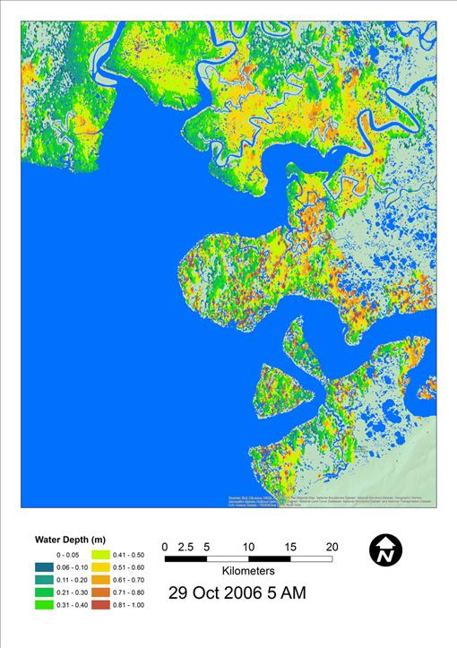
Sample of an inundation map of Hazen Bay with Nelson Island visible on the YK Delta, from a fall storm in 2006. Three villages are located on this island - Tununak, Toksook Bay and Nightmute. Red areas are covered up to a meter in water, or almost 40 inches. Pale green/yellow areas are up to a half meter, or 20 inches. (Created by Jon S. Allen/University of Alaska Anchorage)
"The shape of Norton Sound is just designed to trap water," Ravens said. And funnel it directly toward the lower-sound community of Golovin. Ravens shows a picture of Golovin from a 2011 storm surge. It looks like a lake with many small islands, house rooftops, popping above water. Already the airport and the road to the airport are compromised.
Ravens is compelled to seek additional funding so that his storm surge modeling can be applied to the entire coastline of Alaska. The need is urgent, he says; there will be many more Golovins.
"We can spend enormous amounts of our future resources trying to save places that ultimately can't be saved. Or, we can use our modeling to plan for sustainable communities."
He shakes his head: "The next 20 years are going to be wild."
A version of this story byKathleen McCoy appeared in the Alaska Dispatch News on Sunday, Aug. 16, 2015.
 "Research: Alaska's dissolving coastline, like melted butter on a hot, sunny day" is licensed under a Creative Commons Attribution-NonCommercial 4.0 International License.


